
Page 162 - SST Class 06
P. 162
2. The North Indian Plain From west to east it extends from the
Northern plain lies between the great Aravalli range upto Chhotanagpur plateau
northern mountain and peninsular plateau. in the east. The extensions in the east are
It is formed by the three major rivers – known as Bundelkhand and Baghelkhand
Ganges, Indus, Brahmaputra and their in southern Uttar Pradesh and Chhota-
tributary rivers. This plain covers the area of nagpur in Jharkhand respectively.
Indian states Punjab, Uttar Pradesh, Bihar, The Aravalli range in the north-west gives
Haryana, West Bengal, Assam. The plain is place to the Thar Desert in Rajasthan
very fertile as it is formed by deposition of towards its west and extends deep into
rivers. It is the source of major food grains Pakistan and merges with the Sind desert.
in India. Northern Plain is divided into three Sambhar Lake is the largest of the many salt
sections— Punjab Plains, Ganges Plains, lakes found in the region. The only large
and Brahmaputra Plains. river Luni remains dry for most parts of the
The Shivalik : It descends to the vast plain year.
below. The North Indian plain extends over The Deccan Plateau, south of Vindhyas, is
2,500 km from river Satluj in the west to the perfectly triangular in shape. It is flanked by
Brahmaputra in the east. The plain is made hill ranges on the west and the east known
by two great river systems – the Indus and as Western and Eastern Ghats respectively.
the Ganga. The Western Ghat is also called Sahyadri.
Indus Basins : The area drained by a river The southern parts are known as the Nilgiri,
is known as basin. The Indus originates Anaimalai and the Cardamom hills. The
from the lofty mountains near Lake height of the hill ranges decreases from
Mansarovar in Tibet. The Indus flows south to north. The plateau as a whole
westward and enters Jammu and Kashmir gently slopes west to east. Anai Mudi in
and then Pakistan. In Pakistan, it makes a Kerala (2,695 meters high) is the highest
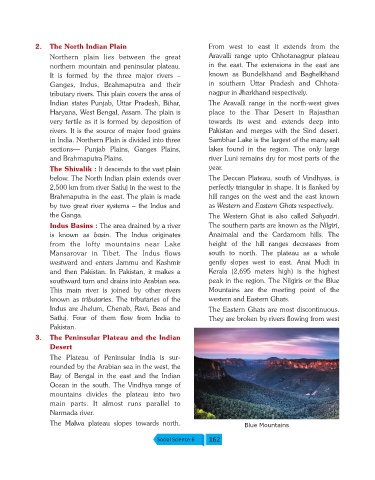
southward turn and drains into Arabian sea. peak in the region. The Nilgiris or the Blue
This main river is joined by other rivers Mountains are the meeting point of the
known as tributaries. The tributaries of the western and Eastern Ghats.
Indus are Jhelum, Chenab, Ravi, Beas and The Eastern Ghats are most discontinuous.
Satluj. Four of them flow from India to They are broken by rivers flowing from west
Pakistan.
3. The Peninsular Plateau and the Indian
Desert
The Plateau of Peninsular India is sur-
rounded by the Arabian sea in the west, the
Bay of Bengal in the east and the Indian
Ocean in the south. The Vindhya range of
mountains divides the plateau into two
main parts. It almost runs parallel to
Narmada river.
The Malwa plateau slopes towards north. Blue Mountains
Social Science-6 162