
Page 97 - EVS Class 04
P. 97
Scales
We use maps to locate places. But, the earth is so big that actual distance
between two places is impossible to be shown on the paper. So, we use a
scale. Map scale is the relationship between distances on a map and
distances on the ground.
For instance, if the distance between two cities is 200 km, we can show it on
a map as 2 cm.
If, 200 km = 2 cm.
Then, our scale is 100 km = 1 cm.
Scales can vary from map to map. A map always contains a scale that it is
using.
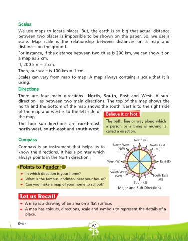
Directions
There are four main directions– North, South, East and West. A sub-
direction lies between two main directions. The top of the map shows the
north and the bottom of the map shows the south. East is to the right side
of the map and west is to the left side of
the map.
The path, line or way along which
The four sub-directions are north-east,
a person or a thing is moving is
north-west, south-east and south-west.
called a direction.
Compass North (N)
North West North East
Compass is an instrument that helps us to
(NW) (NE)
know the directions. It has a pointer which
always points in the North direction.
West (W) East (E)
South West
* In which direction is your home?
(SW) South East
* What is the famous landmark near your house? (SE)
South (S)
* Can you make a map of your home to school?
Major and Sub-Directions
* A map is a drawing of an area on a flat surface.
* A map has colours, directions, scale and symbols to represent the details of a
place.
EVS-4
97