
Page 135 - SST Class 06
P. 135
and geological), thematic map focuses on a we calculate the distance on the string according
specific subject area and uses base data only to the scale given. Large-scale maps show more
as a point of reference for the feature being details than small-scale maps. Suppose, two
mapped. places are 10 km apart, a large-scale map may
Features of a Map show them 10 cm apart while on a small-scale
map, they may be 5 cm apart. Therefore, the size
Whenever we study a map, there are certain
of the map depends upon its scale. The larger the
features that we need to understand. The basic
scale, the clearer are the details.
features of any map are:
DIRECTIONS
1. Distance or scale
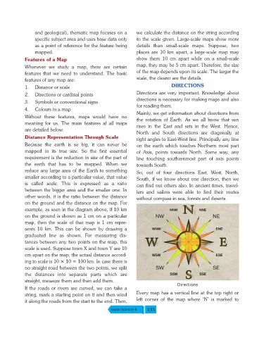
Directions are very important. Knowledge about
2. Directions or cardinal points
directions is necessary for making maps and also
3. Symbols or conventional signs
for reading them.
4. Colours in a map
Mainly, we get information about directions from
Without these features, maps would have no
the rotation of Earth. As we all know that sun
meaning for us. The main features af all maps
rises in the East and sets in the West. Hence,
are detailed below.
North and South directions are diagonally at
Distance Representation Through Scale
right angles to East-West line. Principally any line
Because the earth is so big, it can never be on the earth which touches Northern most part
mapped in its true size. So the first essential of Axis, points towards North. Same way, any
requirement is the reduction in size of the part of line touching southernmost part of axis points
the earth that has to be mapped. When we towards South.
reduce any large area of the Earth to something So, out of four directions East, West, North,
smaller according to a particular value, that value South, if we know about one direction, then we
is called scale. This is expressed as a ratio
can find out others also. In ancient times, travel-
between the bigger area and the smaller one. In
lers and sailors were able to find their routes
other words, it is the ratio between the distance
without compass in sea, forests and deserts.
on the ground and the distance on the map. For
example, as seen in the diagram above, if 10 km
on the ground is shown as 1 cm on a particular
map, then the scale of that map is 1 cm repre-
sents 10 km. This can be shown by drawing a
graduated line as shown. For measuring dis-
tances between any two points on the map, this
scale is used. Suppose town X and town Y are 10
cm apart on the map, the actual distance accord-
ing to scale is 10 × 10 = 100 km. In case there is
no straight road between the two points, we split
the distances into separate parts which are
straight, measure them and then add them.
Directions
If the roads or rivers are curved, we can take a
Every map has a vertical line at the top right or
string, mark a starting point on it and then wind
left corner of the map where ‘N’ is marked to
it along the roads from the start to the end. Then,
Social Science-6 135