
Page 137 - SST Class 06
P. 137
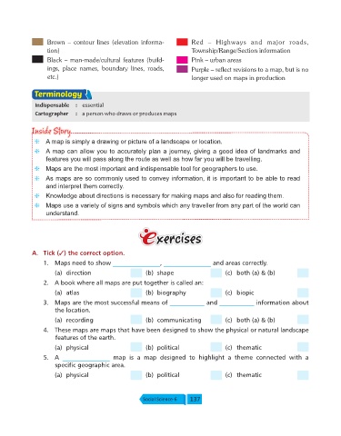
Brown  –  contour  lines  (elevation  informa-         Red  –  Highways  and  major  roads,
                   tion)                                                  Township/Range/Section information

                   Black – man-made/cultural features (build-             Pink – urban areas
                   ings,  place  names,  boundary  lines,  roads,         Purple – reflect revisions to a map, but is no
                   etc.)                                                  longer used on maps in production

              Terminology

              Indispensable  :  essential
              Cartographer    :  a person who draws or produces maps


             Inside Story
             Inside Story
              g  A map is simply a drawing or picture of a landscape or location.
              g  A map can allow you to accurately plan a journey, giving a good idea of landmarks and
                  features you will pass along the route as well as how far you will be travelling.

              g  Maps are the most important and indispensable tool for geographers to use.
              g  As maps are so commonly used to convey information, it is important to be able to read
                  and interpret them correctly.
              g  Knowledge about directions is necessary for making maps and also for reading them.
              g  Maps use a variety of signs and symbols which any traveller from any part of the world can
                  understand.


             A.  Tick (3) the correct option.

                  1.  Maps need to show _______________       , _______________   and areas correctly.
                      (a)  direction                    (b)  shape                     (c)  both (a) & (b)
                  2.  A book where all maps are put together is called an:

                      (a)  atlas                        (b)  biography                 (c)  biopic
                  3.  Maps are the most successful means of ___________         and ___________    information about
                      the location.
                      (a)  recording                    (b)  communicating             (c)  both (a) & (b)

                  4.  These maps are maps that have been designed to show the physical or natural landscape
                      features of the earth.
                      (a)  physical                     (b)  political                 (c)  thematic
                  5.  A  _______________     map  is  a  map  designed  to  highlight  a  theme  connected  with  a
                      specific geographic area.
                      (a)  physical                     (b)  political                 (c)  thematic


                                                       Social Science-6  137